Urban and peri-urban forests in Greater Tunis
Year : 2011/2014
Client: Ministry of Environment and Sustainable Development
Location: Greater Tunis, Tunisia
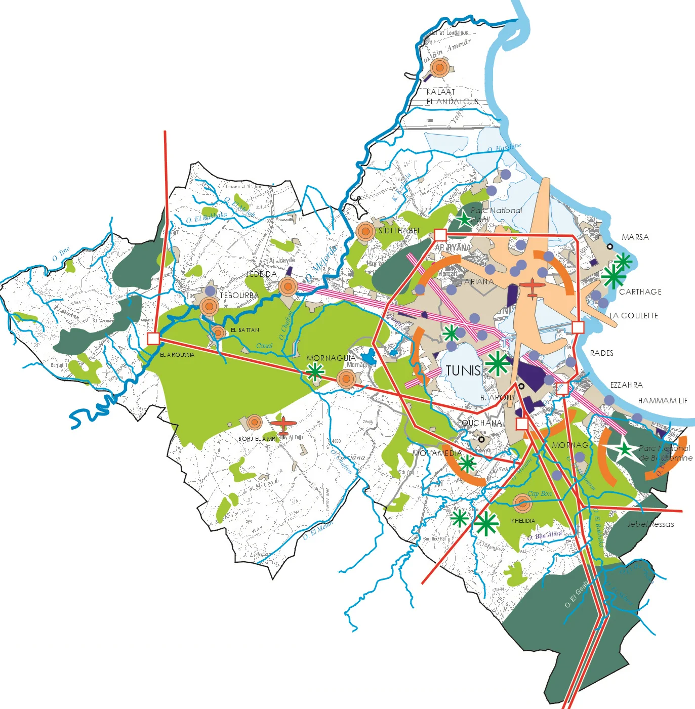
This study, conducted in 3 phases, identifies urban and suburban forest sites in Greater Tunis and visualizes the role and the place they occupy today in this city.
PHASE 1:
Identification of forest in each governorate, by combining two levels of intervention: Literature Interpretation and Mapping (maps, plans, studies, inventories ...) and field prospecting, detailed, crossed with an interpretation of the cards.
Classification of forests in Greater Tunis: fitted, threatened Forest, rehabilitated, etc.
Establishment of listings for each category of site
Forest sites proposed to be developed and / or value for the development of the second phase.
PHASE 2:
The overall approach of developing a forest management plan follows the same logic based on 4 phases. The first concerns the collection of information on the area to be developed; the second is that of the analysis; the third is to set objectives and the development of guidelines and finally the last is that of planning. Regarding this study we first proceed to collect information about the site followed by a detailed analysis of each forest by following the six steps detailed below:
First step: study of the urban and socio-economic environment
The aim is to give a reading of the territory in which falls the forest and identify existing access around the forest site (relationship with the urban fabric in particular). It is question for this step of (1) the analysis of urban or peri-urban location of the forest and nature of contacts with the city (2) past dynamics of forest land associated with urban sprawl, (3 ) future projects planned or spontaneous urbanization, new infrastructure, ...
Step Two: Historical Overview on the site
This is a comprehensive analysis of existing information in the site under study, its evolution in time and space, the reports of the neighboring populations to this site, the management procedures of this website. It is also very important to identify the nature of e-purposet users (origin, mode of transport, activities).
Step Three: Physical characteristics
This analysis will concern climate, soil characteristics, water .....
Fourth step: study of the fauna and flora
The purpose of the flora-fauna study is to choose the solution that best balances the opportunity of the project with the preservation of the environment. The fauna / flora study must (1) identify and precisely locate sensitive natural areas in the study area affected by the project subject to impact assessment; (2) conduct a field inventory of plant and animal species that these natural areas are home to periods favorable for their observations.
Step Five: determination of landscape features of the site and setting up diverse potential of the site
Analysis of landscape issues aims to guide development to the permanence of forest landscapes. The landscape analysis to define and locate landscape issues of the forest. It will be performed in two ways. (1) The localization of high landscape sensitivity spaces areas exposed to public view from the inside but also from outside the forest, (2)Inventory of landscape elements contributing to the site attractive to the public.
Step Six: Identification of malfunctions, threats and weak points of each site
This is to detect the elements that provide a sense of insecurity to future visitors or give a bad impression on the premises (degraded appearance).
PHASE 3:
In progress